By: Liam McGuire
It takes a view from above to see what is happening below. This past December I was reacquainted with the snow covered landscapes of Ontario, as white terrain stretched out underneath my flight. As we descended, streetlights below illuminated the urban layout of my hometown Ottawa. As I craned my neck to the windowpane for a better look, my view from above told a story of how this city has grown. A large black swath of darkness interrupted the city lights, separating the urban core and the surrounding constellation of suburban communities.
This observation reignited old thoughts about the Greenbelt that surrounds Ottawa’s core urban region. The greenbelt in itself is not a new idea. Among other influences, the idea of an environmental buffer zone comes from the Garden City concept of Ebenezer Howard. In Howard’s time, overpopulation was a huge worry for cities, and the residential communities on the other side of the greenbelt offered relief to the bustling industrial core. Lewis Mumford sums it up well: “the Garden City, as Howard defined it, is not a suburb but the antithesis of a suburb: not a more rural retreat, but a more integrated foundation for an effective urban life.”
If urban planners wish to preserve that foundation for an effective urban life, they need to sit down and think about the green belt in a contemporary sense. My view from above observed communities that had leapfrogged, trading density for the greenfield development of former farmland. Abundant green space is by all means necessary to keep a strong ecological balance, however the city’s inability to enforce urban density has allowed exponential amounts of sprawl. Population forecasts for the outer greenbelt communities are high. By 2031, Orlean’s population will grow by 25%, Kanata/Stittsville by 83%, and Riverside South Leitrim by 381%. Inside the Greenbelt, the population will grow a meager 7%. So much for “smart growth.”
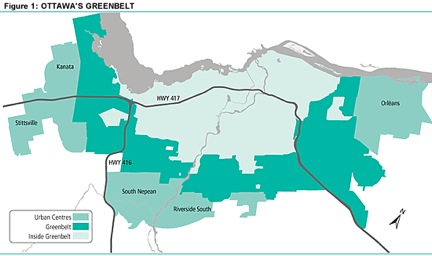
Inevitably this will place huge pressures on the infrastructure of the city. Jobs will continue to be located in the urban core, and highways will need to expand rapidly. Judging by Ottawa’s track record with municipal light rail, there will be no mass transit solution anytime soon. It's time to rethink Ottawa’s master plan, and the upcoming National Capital Commission (NCC) greenbelt review is the perfect time to do it. Starting thoughts range from planning for density in the core to speeding up mass transit plans, however my purpose is just to get the conversation started. Ottawa is a beautiful city, and we pride ourselves on it. I’m not advocating tearing down our Greenbelt, I’m advocating that we start to make it a functional part of the city’s ecology. The City of Ottawa and the NCC need to consider the view from above as they plan for the future. This requires an approach of balancing environmental and infrastructural considerations, and finding city officials and community leaders who are up to the challenge.
Liam McGuire is a Master's student in Urban Geography at the University of British Columbia. He completed his Honour's BA at Trent University in 2009 in Human Geography and Political Science. Liam is very passionate about cities; their development, spatial growth and demographics. He has many opinions and insights about how cities should develop and could be contacted at: liam.mcguire@geog.ubc.ca
An inclusionary dialogue on anything and everything green from the minds of two Canadian university students with the intention of exchanging ideas and opinions pertaining to the environment. We encourage you to contribute to the blog as a reader, commenter and even an author. We're all part of the environment and sharing ideas is a role we can all play.
Showing posts with label Population Growth. Show all posts
Sunday, January 23, 2011
Tuesday, March 9, 2010
No need to salt our roads: Spring is approaching and salt poisons our water…
A geological study from the University of Toronto has found that road salt poses numerous threats to groundwater and water quality. Their research findings come from a study based on Pickering, ON. Pickering is a GTA community relatively close to the 401 highway and a community that has witnessed a lot of suburban growth. Both the 401 and suburban roads use copious amounts of road salt for highway and road safety and to minimize the likelihood of accidents. Alas, in the Pickering context, a lot of this salt has ended up in a nearby watershed called Frenchman’s Bay, a lagoon on the shores of Lake Ontario.
The geologists found that over 3,600 tonnes of road salt end up in Frenchman’s Bay every winter due to direct runoff in creeks and streams. It is no coincidence that the fish population in this lagoon has been declining due to increased levels of salinity. Putting the salinity levels in some context, it is estimated that the lagoon has levels of salt that closely resemble ocean water. Higher levels of salinity simply contaminate the waters and drive the younger fish population away. Younger fish, unlike older fish, do not have the capacity to cope with saline intrusions because they are not used to it.
The impacts of road salt on Pickering's ground and surface water imply a higher than average amount of road salt usage. In Canada, about five million tonnes, or approximately 150 kilograms per Canadian, is used on roads each year to make them safe for travel in winter. A lot of this road salt is applied to roads in Ontario and Quebec.
Where does government intervention fit into all of this? Well, Environment Canada has recognized the “adverse” impacts of salt on wildlife, plants, water, soil etc. In the past, they considered adding road salt to the nation’s list of toxic substances, but... that never happened. Six years ago, the government instituted a “voluntary code of practices” to "encourage municipalities and others to use the de-icer more sparingly", while maintaining highway safety.
It is the province though that is using road salt for the 401 highway, not the municipalities. Plus, communities like Pickering are growing rapidly placing more pressure on local government to salt their roads because it is the most economically sensible way of ensuring road safety.
Voluntary code of practices should not be applied in this particular case. The geological study provides convincing evidence that road salt has negative ramifications for the large Pickering watershed. While other options are currently being reviewed, I think that municipalities must establish regulations that govern the use of road salt to account for their environmental impacts. Quotas must be established until we come up with more sophisticated engineering solutions.
Key message: The use of road salt helps make our roads safer at the expense of contaminating water quality, declining fish populations and wildlife. In an era where we are trying to sensibly integrate public policy with science, we need to find more practical alternatives that benefit society and nature.
Sunday, February 14, 2010
Using Nature to sell Housing Development
I recently started working on a project for one of my Geography courses titled “The Rural-Urban Fringe”. The focus of this project is on nature and peri-urban development. In essence, my group has to talk about how nature is used to sell and promote housing development in exurban areas. An exurb is a non-rural residential community located outside a city, beyond the suburbs.
Many could argue that Peterborough is an exurb. I would argue that it is a city (pop ~80,000). However, Peterborough’s fringe areas (located outside of the urban environment) are experiencing the construction of numerous sub-divisions. Growth in the sub-divisions? O yeah, those urbanites (many of whom lived in places like Toronto) are seeking housing outside of the urban area where they are closer to nature, have more lot space and the ability to develop a sense of community.
As part of the project, I intend on biking around the fringe areas of the city to collect and document evidence of nature being used to market housing developments. The sub-division that I’m biking to tomorrow is called “Natural Habitat”. The developers have used this title because it’s catchy and will probably sell more and more homes. Underneath the title it reads “conservation lands”, “golf courses”, and “waterfront setting”. So, if you live in this sub-division you will have access to all of these wonderful things.
Empirical evidence suggests that residents of new large lot subdivisions (natural habitat for example) on once rural land have become worried about more residential growth opposing condos, apartments, theatres, restaurants and shopping malls near their homes. These residents escaped the urban setting to get away from these things. However, new growth is happening all over Peterborough as evidenced by the construction of sub-divisions.
This new growth is accompanied with various amenities which makes the rural life congested, chaotic and begins to see some attributes of the urban. Having said this, the housing developments are still selling because residents can enjoy their large open spaces. Being close to Big Box stores is just a bonus, although it will eventually erode any sense of community and pull people away from the downtown (thus eroding the local economy).
Sometimes families are attracted by a small town’s charm and will choose to buy a house distant from the city- only to find that the town’s physical character was soon compromised by excessive new development. The danger is that once one sub-division is built (near nature), this provides more of an economic impetus to develop another one because housing demand is good. Alas, this defeats the purpose which is to find a small community that can provide social and economic needs for these “exurbanites”.
Key message: Humans have always been in touch with nature. Over the years, we have and continue to witness mass urbanization which compromises nature, the environment and our access to green and open spaces. Thus, when sub-divisions are built in places like Peterborough (relatively close to Toronto), and when they use images like golf courses, trees and rivers, people are immediately attracted to it because it will ostensibly provide them with a healthier and more enjoyable lifestyle. There are burning ironies here that I will not discuss. They will be shared as I progress into my research.
Friday, February 5, 2010
Some thoughts on air pollution in Toronto…
Air pollution is an egregious urban health issue of our time. In Toronto, on-road and off-road vehicles are estimated to generate 38 percent of nitrogen dioxide (NO2), 38 percent of sulphur dioxide (SO2), 74 percent of carbon dioxide (CO2) and 15 percent of volatile organic compounds (VOC) emissions. These are all of the emissions that contribute to poor air quality and respiratory illnesses. Toronto has the highest summertime levels of fine particulates and the highest annual mean levels of nitrogen dioxide levels.
According to the Pollution Probe, smog alert days have been on the rise for the city and this is largely attributed to an increased number of vehicles on the road. There were 27 smog alert days in 2002, up from just 3 in the year 2000. Since the 1980s, there has been a steady increase in ozone levels in Toronto. Ozone triggers asthmatic attacks among those suffering chronically from the disease. Also over the last two decades, the number of vehicles entering the city each weekday morning increased by 75 percent.
An increase in the number of vehicles entering the city has numerous implications. Toronto finds itself situated in the heart of the Greater Golden Horseshoe. As the region continues to grow in population, urban sprawl may lead to the worsening of air quality conditions for many municipalities.
It is estimated that 3.5 million people will join the Greater Golden Horseshoe by 2035; this will lead to an expanding transportation sector that is conducive to automobility and hopefully public transit. However, public transit will have to be given policy weight not only for reasons of smart growth and providing for densification, but alleviating the pernicious air pollutant sources derived from motor vehicles.
From an urban and regional planning perspective, we have to better optimize regional transportation. To obtain high efficiency and environmental quality, we have to start planning (increasing ridership rates) our alternative transportation systems i.e. Go Transit, Via Rail and light-rail transit. These transit services are gaining popularity in an era of high gas prices and highway traffic congestion- but we can do better especially if we are concerned about public health and air pollution issues.
Epidemiological research has conclusively proven that exposure to air pollution can exacerbate asthma conditions, induce heart attacks, reduce overall lung function, trigger cardiovascular diseases and bring about chronic obstructive pulmonary disease (COPD), just to name a few. Air pollution is a complex issue; expanding regional public transit for the Greater Golden Horseshoe is something that must be aggressively pursued.
I provided some stats at the beginning of the post to really illustrate how automobiles contribute greatly to air pollution. Our elected officials have heard numerous arguments and have seen empirical examples of how public transit helps increase regional efficiency, transportation flow, create jobs and is "good for the environment". What is not heard as much is the air pollution argument and how regional public transit can drastically decrease "regional air pollutant output".
Key Message: Population growth will add more pressures to regional public transit systems and if they are not managed well, as in we see ridership decrease, then air pollution and the nasty symptoms of climate change are bound to worsen. Urban planning needs to address this more clearly. Civil servants and leaders of our cities must allocate more resources into public transportation.
Tuesday, December 15, 2009
The Future of Cities in the U.S.
A number of months ago, I blogged about an article written by Edward Glaeser, a Professor of Economics at Harvard. Many of the arguments from his article are found in the youtube clip above. I don't agree with all of his points, but he makes many convincing arguments.
His research focus is on the economics of housing. On the environmental side of things, he has published papers on how climate should influence how cities grow. California for example, has the most temperate climate in the country and as a result, homes use less heat in the winter and less electricity in the summer. Yet, many environmentalists oppose any sort of development in these places because they want to preserve the natural environment.
To quote Glaeser, "a new building in California, as opposed to Texas, reduces America’s carbon emissions. Yet, instead of fighting to make it easier to build in California, environmentalists have played a significant role in stemming the growth of America’s greenest cities." Places like Houston are sprawling rapidly. Many of the homes constructed in Houston's suburban communities require air conditioning to run 24/7 because of the unbearable humidity. California, which is growing at 8%, has strict regulations regarding housing development. This is unfortunate because higher densities are needed in places like California (better climate) and not in places like Houston which use artificial cooling to keep everyone happy!
In the video clip, Glaeser contrasts California with places like Houston, Dallas and Atlanta; these three areas are both among the nation’s five most carbon-intensive living areas and among the three fastest-growing metropolitan areas.
To learn more about this topic, see the video.
Friday, December 11, 2009
Mixed land uses: Downtown Peterborough...
As part of a class assignment, I recently submitted a letter to Peterborough’s Director of Planning and Development Services. It was a letter regarding Peterborough’s downtown and how it can greatly benefit from incorporating mixed land uses. By mixed land uses, I mean combining commercial and residential units together to optimize space and make the downtown more compact. Below, you will find a compressed version of the letter:
As a student studying geography and the environment and learning about the importance of urban densification for sustainability and economic efficiency, the present growth in Peterborough concerns me. I recommend that the city use an intensification strategy to bring about more mixed land uses in the downtown area. Intensification is a common urban planning strategy for achieving compactness, using land more efficiently by increasing the density of development and activity.
I believe that such an undertaking will help boost the economic vibrancy of the local economy and increase the densification of the urban growth centre, ultimately benefiting both the environment and the economy.
Without stifling the city’s housing market, new commercial development in the city should be mixed with residential units. Mixed land use reduces the probability of using a car for commuting, shopping and leisure trips because jobs, shops and leisure facilities are located nearby. This would be a win-win for Peterborough’s local economy as residents would be living closer to local business and retail stores and farther away from the Big-Box stores like Wal-Mart and Future Shop.
As an example, Harvey’s fast food restaurant at the corner of Sherbrooke and Water Street has tremendous potential to turn into a mixed land use development. Located next to the Otonabee River and in the heart of downtown, it can integrate local businesses, retail, restaurants and residential uses. In addition, such a development would replace the eye-sore that currently occupies the land and turn it into a more compact, liveable and sustainable form.
By mixing commercial and residential units, not only would the city increase the densification of the downtown, but it would be ensuring that many services are within a reasonable distance, thus encouraging cycling and walking. Other environmental benefits to this would include a reduction in air pollution and traffic congestion, as well as to stimulate the interaction of residents, by increasing pedestrian traffic and generally improving neighbourhood charm.
By mixing land uses, we are increasing the number of people concentrated within an existing urban area, and thus these people are now living closer to businesses, public amenities and even recreational activities. Recreational activities would include parks, beaches and campgrounds. Therefore, this might generate more revenue for the restaurant, and stimulate more business activity for other services and commercial establishments, thereby directing a greater flow of capital towards Peterborough’s local businesses and less towards Big-Box stores around the sub-divisions.
One of the main objectives of Peterborough’s new amendment to their Official plan is to provide greater choice in housing types to meet the needs of people at all stages in life. I would challenge developers by saying that housing and commerce will increasingly be concentrated in the urban area; so exploring multi-unit housing complexes near the downtown can be profitable.
As other cities in the Greater Golden Horseshoe increase their urban densities through more compact and mixed use development, Peterborough will face pressures to follow suit.
Key message: Developing Peterborough into a more economically and environmentally sustainable city is a process that might take many years; however, engaging private developers on this matter is a good first step.
Friday, November 6, 2009
Water use per person in the U.S. is nearly 30 percent lower than in 1975...
This post is from Peter Gleick's blog: City Brights
Ponder this paradox...
"Water Number: 410 billion gallons per day in 2005 compared to 413 billion gallons per day in 2000. This is the total amount of water withdrawn in the U.S. for all purposes (residential, commercial, agricultural, industrial, and power plant cooling). Despite continuing population growth, despite continued economic growth, total water use in the United States is effectively unchanged from five years ago. Even more remarkable? Water use today is lower than it was 30 years ago, in 1975. And on a per-capita basis, the drop is dramatic: Water use per person in the U.S. is nearly 30 percent lower than in 1975."
"It used to take 200 tons of water to make a ton of steel. Now steel plants in the U.S. use less than 20 tons of water to make a ton of steel. That is a 90% reduction."
To read more on this topic, click here.
As you read, keep in mind population growth as a major factor. U.S. population circa 1975: 215,000,000. U.S. population circa 2009: 305,000,000. Therefore, total water use per capita should theoretically be lower, given bigger population and less water available for each person. Water droughts and shortages have been more common over the past 20 years and climate change has reduced the quantity of water in major U.S. rivers.
Sunday, August 9, 2009
The importance of the potato in the 18th century...
How do places urbanize? Usually people migrate to cities because of the multiplicity of choice… You have quick and easy access to public transportation, numerous urban amenities and tonnes of housing options to choose from. When places urbanize, the population concomitantly increases… naturally. For hundreds of years we have been studying population growth examining factors that depopulate and populate areas. This has always been a curious humanitarian question and it is only gaining more research interest as our population surpasses the 6.8 billion mark.
Over the course of civilization, diseases like Black Death, malaria and other deadly epidemics have obliterated populations. However, we have also seen tremendous population growth since the 1950s particularly in India, China, Brazil, the United States and Europe. What exactly has been the cause of such population growth? Is it natural resources, is it the aforementioned urban amenities or is it something else?
The contemporary population question is being studied widely across the world. Interestingly, if we look at the world in the 18th and 19th century, the discovery of the potato not only led to a 22% rise in population, but a 47% rise in urbanization. Nathan Nunn and Nancy Qian have done research on the importance of nutrition to economic development. Their findings on the potato are fascinating.
The discovery of the potato was interconnected through geography, the environment, economics and health. After all, potatoes are an inexpensive crop to cultivate and subsequently eat, highly nutritious and are geographically suitable to be cultivated in many parts of the world including Northern Europe, Asia and even Northern Africa.
The discovery of potatoes led to population growth and urbanization in the 18th and 19th century. In the 21st century there are numerous factors contributing to population growth and decline. It seems however, that the discovery of natural resources are far more important today than any one nutritional crop like potatoes.
This is because natural resources have much more economic value and wealth today because of scarcity issues - oil, water and timber just to name a few examples. But natural resource discovery has at times --both historically and contemporarily-- led to conflict and war… factors that lead to depopulation. I wonder if there will be a study that shows the correlation between natural resource discovery and depopulation. Anyway, see Nathan Nunn and Nancy Qian's study on the discovery of the potato and urbanization.
Subscribe to:
Posts (Atom)