Showing posts with label Geography. Show all posts

Sunday, January 23, 2011

Guest Entry: A View from Above: Examining Ottawa’s Greenbelt

By: Liam McGuire

Photo Courtesy and Copyright of Jason Walton

It takes a view from above to see what is happening below. This past December I was reacquainted with the snow covered landscapes of Ontario, as white terrain stretched out underneath my flight. As we descended, streetlights below illuminated the urban layout of my hometown Ottawa. As I craned my neck to the windowpane for a better look, my view from above told a story of how this city has grown. A large black swath of darkness interrupted the city lights, separating the urban core and the surrounding constellation of suburban communities.

This observation reignited old thoughts about the Greenbelt that surrounds Ottawa’s core urban region. The greenbelt in itself is not a new idea. Among other influences, the idea of an environmental buffer zone comes from the Garden City concept of Ebenezer Howard. In Howard’s time, overpopulation was a huge worry for cities, and the residential communities on the other side of the greenbelt offered relief to the bustling industrial core. Lewis Mumford sums it up well: “the Garden City, as Howard defined it, is not a suburb but the antithesis of a suburb: not a more rural retreat, but a more integrated foundation for an effective urban life.”


Garden City Plan (Ebenezer Howard)

If urban planners wish to preserve that foundation for an effective urban life, they need to sit down and think about the green belt in a contemporary sense. My view from above observed communities that had leapfrogged, trading density for the greenfield development of former farmland. Abundant green space is by all means necessary to keep a strong ecological balance, however the city’s inability to enforce urban density has allowed exponential amounts of sprawl. Population forecasts for the outer greenbelt communities are high. By 2031, Orlean’s population will grow by 25%, Kanata/Stittsville by 83%, and Riverside South Leitrim by 381%. Inside the Greenbelt, the population will grow a meager 7%. So much for “smart growth.”

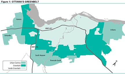
Ottawa's Greenbelt (City of Ottawa)


Ottawa in 1955 (Natural Resources Canada)

Ottawa in 2002 (Natural Resources Canada)

Inevitably this will place huge pressures on the infrastructure of the city. Jobs will continue to be located in the urban core, and highways will need to expand rapidly. Judging by Ottawa’s track record with municipal light rail, there will be no mass transit solution anytime soon. It's time to rethink Ottawa’s master plan, and the upcoming National Capital Commission (NCC) greenbelt review is the perfect time to do it. Starting thoughts range from planning for density in the core to speeding up mass transit plans, however my purpose is just to get the conversation started. Ottawa is a beautiful city, and we pride ourselves on it. I’m not advocating tearing down our Greenbelt, I’m advocating that we start to make it a functional part of the city’s ecology. The City of Ottawa and the NCC need to consider the view from above as they plan for the future. This requires an approach of balancing environmental and infrastructural considerations, and finding city officials and community leaders who are up to the challenge.

Liam McGuire is a Master's student in Urban Geography at the University of British Columbia. He completed his Honour's BA at Trent University in 2009 in Human Geography and Political Science. Liam is very passionate about cities; their development, spatial growth and demographics. He has many opinions and insights about how cities should develop and could be contacted at: liam.mcguire@geog.ubc.ca

Tuesday, August 24, 2010

Water in China Part III

Image above: The Yangtze River. China's longest river, 6,397 km in length. The Yangtze River flows across 13 provinces, with many branches, such as Min River, Wu River, Xiang River, Han River, Huangpu River and more.

Image credit: Odd and Funny Blogspot.

**Lcd: litres per capita per day**

This post will conclude the three part series of water in china. You can read part one here, and part two here. Most of this information is derived from Peter Gleick's publication titled "China and Water".

China is slowly starting to introduce water pricing to induce conservation. Such measures in water management have already been brought about in places like Guelph, Ontario. For a long time, water utilities have been subsidized by the Central government which has reduced the need to encourage water conservation. But now, with sustainable water management as a long-term national goal, Chinese cities are slowly implementing water pricing. In Beijing, price for domestic water use have more than doubled 4 yuan per cubic meter. For water intensive activities such as commercial car washing, it cost 45 yuan per cubic meter.

In Shenzhen (Southern China) local government officials have called for initiatives to recycle water, introduce rainwater harvesting and cut back on overall water use. Price-driven quotas are being introduced in Southern China, which means that urban homes that use more than 210 lcd (Canadians use about 343 lcd) will have to pay a surcharge on additional use. The more you consume past the 210 maximum, the more you pay for.

Separate quotas are being imposed on the various water users which includes industrial, agriculture, residential and commercial. The key point is that local governments in Southern China (where water is more abundant) are adopting flexible pricing systems based on different water users; this is an important step because the industrial and agriculture sectors use lots of water and constitute a greater share of GDP output. The greatest cuts need to happen in the residential sector; but this can only happen with education and good incentives to use less. Moreover, Northern cities should follow Beijing's initiatives and adopt smarter pricing systems. Northern cities have less water than southern ones yet they are slower to bring about water management initiatives. Reducing national water use requires participation from each city.

According to Peter Gleick, China has invariably experienced poor public participation grades for water projects and water policy. The Three Gorges Dam is notorious for its non-existent public consultation process which led to the displacement of 1.3 million people. Gleick writes:

“A major environmental law passed in China in 2003 for the first time ostensibly encouraged public participation in environmental decision making. This law, the Environmental Impact Assessment (EIA) Law requires all major construction projects to undertake an impact assessment". Further, it states “The nation encourages relevant units, experts and the public to participate in the EIA process in appropriate ways”. In addition, the law states that “the institutions should seriously consider the opinions of the relevant units, experts and the public” and “should attach explanations for adopting or not adopting the opinions".

Sounds like a well thought out law; however, its effectiveness is questionable. Some citizens have taken many matters into their own hands; some have sued chemical plants to force compensation for health and environmental damages (due to polluted water supply) or to make more environmental information accessible to the public. With China's explosive growth -- in economy and population -- and with the indispensable role water plays for economic growth –through dams, wastewater, agriculture, irrigation and forthcoming desalination—it is clear that it is a extremely valuable resource that will shape China’s future.

With sensible pricing structures being introduced, and with wastewater treatment plants helping provide cleaner water, the test for China will be whether it can engage more of its citizens in an equitable and efficient manner. Public participation should not be viewed as a hindrance to dam construction; citizens are demanding that such construction be built in a way that minimizes harm to their livelihoods and that effective compensation measures are in place for those affected by it.

As Gleick says “Sustainable water management has long taken a backseat to the Chinese for economic growth. With supplies dwindling, the Chinese will start conserving it through pricing and through desalination construction" (which is problematic but necessary considering China’s population).

Patricia Adams, an executive director of Probe International says that cities like Beijing can't keep going further with larger engineering projects to take water from other peoples' watersheds. "Beijing needs to implement regulatory and pricing regimes that reflect the scarcity of water in their own watershed and induce conservation and watershed rehabilitation". Clearly, the country needs some sort of water education program to inform people not only about conservation but about the impact of certain chemicals and contaminants to reduce health impacts from exposure.

Key message: If China truly wants to achieve sustainable water management, it will need to ensure that its central governments puts pressure on local governments to develop the legal, technological, and institutional tools to clean up water pollution, reduce wasteful and inefficient uses of water, restore natural ecosystems, and develop sustainable sources of supply.

** China is spending 500 billion yuan (77 billion Canadian) on the South-North Water Diversion Project. It will be completed by 2050 and is the largest scheme of its type in the world. It will divert about 44.8 billion cubic meters of water per year from various rivers. Hopefully, this project is accompanied with extensive water conservation education and with water pricing systems. You can read about this project here.

Saturday, August 7, 2010

Development charges and the urban growth fund

In June 2009, I was reading a book by Jeb Brugmann titled Welcome to the Urban Revolution: How cities are changing the world. It was very thought provoking and well-written providing an excellent analysis of the historical, contemporary and future salience of cities in shaping the world. The book presents a thorough overview of the connection between high density areas in the developing world and the influence this has on establishing both local markets and globalization.

Here is excerpt from the book that inspired a section of my honours thesis and a fourth year research paper:

“There are two aspects to density in the growth of cities. Proximity reduces time and energy and therefore the cost required to move people and materials around to achieve any objective. Take an urban water system. If we are building a water system for a suburban neighbourhood where homes are 120 feet apart versus a downtown neighbourhood where homes are twenty feet apart, we have to use one hundred feet of extra pipe for each home in the lower-density neighbourhood. If each neighbourhood has one hundred houses, then a higher-density neighbourhood saves an impressive two miles of pipe – not to mention the costs for installation and maintenance and for pumping the water through it. But in my city, a person living in a low-density neighbourhood pays the same rate for water as the people in my high density neighbourhood. The water department loses money on the low-density neighbourhood, and our neighbourhood must help make up the difference through our water rates and tax payments”.

Jeb is referring to Toronto in this case. While this sort of system may not be true for all jurisdictions, it nonetheless provides an illustration of the link between density and public service payments associated with housing location and water distribution.

To remedy this inequitable system, and to encourage growth in urban areas, I wanted to share a proposal with you. As I learned from my research, in Peterborough, when developers want to build sub-divisions in the fringes of urban areas, they are required to pay development charges for the houses to cover the costs of piping installation, water delivery, treatment and storage. Why? Because it costs the City's water utilities a lot more money to build additional (and longer pipes) and to deliver the water to those homes because they are farther away from the water treatment plant. Longer distance from the plant means more money. So in theory, the development charges cover these infrastructural costs.

Under my proposed system, sub-division developers would continue to pay the respective development fee per sub-division lot. However, 10-15 percent of this charge would go toward an “urban growth fund” used to encourage and subsidize developers wishing to build in the city’s built area (i.e. areas that are already paved over and could use redevelopment).

To illustrate a fictitious situation, let’s say a developer was paying $5,000 per lot in development charges. The sub-division has about 200 lots. Therefore, $5,000 x 200 lots = $1,000,000.
Therefore, 0.15 x 5000 (per sub-division lot) = $750. $750 per lot x 200 lots (total number of lots in subdivision) = $150,000. Thus, of the $1,000,000 raised in development fees from the sub-division, $150,000 would be directed towards the urban growth fund.

This would be used to subsidize developers wishing to build in the urban growth area and overtime, this can significantly alleviate pressure on public service provision. Remember, even if the development charge is paid by the developer, over time, it still costs more money and uses more energy to distribute water to those homes farther away from the system. The urban growth fund is for long-term sustainability to encourage more urban development and to keep public service provision more efficient and more local.

The $5000 figure is simply an arbitrary fee; the cost of the development charges for each sub-division could be different and set by the city. Setting the development charges for each sub-division can be raised or lowered depending on the topography of the sub-division’s land, distance from public facilities (water, wastewater and electricity), amount of impervious cover already on site and other factors as well. I propose the arbitrary fee of $5000 to illustrate how revenue could be generated, especially if the city wishes to intensify land uses and create a more compact urban form.

The proposed urban growth fund can raise significant revenue and provide more budgetary flexibility for a city. This could be one solution for cities (such as the one Jeb describes) to ensure that water departments are not unfairly charging higher water rates for those high-density neighbourhoods while concomitantly encouraging more urban growth (which could save costs in the long-term). Whether such a system would ever materialize is up for debate; I figure there are many policy tools we could use, but putting them into practice can be a difficult and laborious process.

Key message: Water rates in any jurisdiction should be adjusted based on density and proximity to water mains and pipes; this is an equitable approach to public service provision. If a jurisdiction has set suburban development charges for public service provision, then it would be wise to redistribute some of this revenue to mechanisms that can encourage more urban growth and overtime reduce pressure on undeveloped land.

Wednesday, July 21, 2010

Apps from Google Maps...

The Planning Pool blog recently published a post on the top ten google map tricks that you should know; from planning a bike trip (as Chris is doing) to getting real time traffic information in your area. "My Maps" has an application called Roof Ray, which lets people find their house on Google Maps, draw their roof, and then calculate the cost and payback period for installing solar panels. I found this application the most intriguing.

You can view more "tricks" here.

Tuesday, July 20, 2010

Bottled Water from Fiji


I went to a coffee shop today in Hong Kong's Central Business District. While waiting in line, I saw some guy buy two bottles of Fiji Water priced at HK$19 a piece ($2.57 CAN per bottle). Yeah, that's right, I actually walked over to the bottled water section after I purchased my coffee to check out the outrageous prices of these products.

Of all the forms of bottled water, I think Fiji water is the worst in terms of its negative ramifications on the environment. Not only that, but the price is exorbitant (you pay a premium for this stuff, it cost more than Dasani and definitely more than Volvic). Also, it has a high energy intensity.

As Peter Gleick demonstrated in a paper, the energy intensity of bottled water is measured by manufacturing the plastic bottle, treatment, cooling and transportation. In the transportation category, Fiji is probably the worst. Indeed, North American cities like LA have high demand for Fiji water. The transportation energy cost of getting the water from Fiji to LA is 4 megajoules (MJ). To put that in perspective, producing tap water requires about 0.005 MJ for treatment and distribution. Transporting Fiji water from Fiji to Hong Kong has a smaller transportation energy cost, nonetheless, it is still an issue worth discussing.

Don't worry, I am not forgetting about the economic side of this argument. Fiji water is in high demand and thus profitable for those who make it. Instead of going on a huge rant about why bottled water from Fiji is problematic, I'll leave you to read David Zetland's blog post (which is hilarious and bang on) and touches more on the economics of the issue. I just thought I would point to a few facts.

Saturday, June 26, 2010

Hong Kong: Geography, Climate and Population

Image of Hong Kong from Victoria Peak (552 meters in height).

Seeing as I'll be in Hong Kong for the next two months, many of my posts will be about this City and its progress and challenges surrounding the environment. Don’t worry though, every so often I’ll post something that isn’t entirely focussed on the “environment” so you don’t get too bored.

This post is a general overview of Hong Kong’s geography, climate and population. Yes, this information is widely available on Wikipedia but I figured I could break it down so you know a little bit more about this very vibrant and dynamic place. As someone who studied the Environment and Human Geography for the past four years, the least I could do is provide some information about place, location, demographics and density.

To begin, Hong Kong is a Special Administrative Region (SAR) of China. This means that it is a part of Mainland China but has its own economic and political system "one country, two systems".

Hong Kong has the fourth highest population density in the world in terms of special regions/countries (Macau, Monaco and Singapore are first, second and third respectively). The population of Hong Kong is just over 7,000,000 people with a total land area of 1,104 square kilometers; this puts its population density at 6,480 persons per km2 (Toronto's is 3,972 persons per km2).

Hong Kong’s 1,104 square kilometers is spread out over three regions that constitute the City, these regions include New Territories, Kowloon and Hong Kong Island. New Territories is the most northern region located just below Mainland China. It is the biggest by land size but has the smallest population density at 3,820 persons per km2. Hong Kong Island (where I work) is the smallest by land size and has a density of 16,220 persons per km2. The airport is located on Lantau Island which is another island of Hong Kong.

Finally, I live on Kowloon Peninsula which has the highest density at 43,970 persons per km2 (it’s intense but I love it). If you look at the map, there is an area in Kowloon called “Mong Kok”. The population density is intense, I reckon it has the highest density in Hong Kong and is one of the most dense places in the world.

Hong Kong has a humid sub-tropical climate (very humid and wet in the summer, very dry in the winter). Right now, the average temperature has been around 30 degrees Celsius with intense humidity and lots of rain. Victoria Harbour is the body of water between Kowloon and Hong Kong Islands. The City is also surrounded by a number of mountains and peaks which you can view here. Hong Kong is just south of the Tropic of Cancer. The South China Sea is immediately south of Hong Kong Island which is excellent for its exports and international trade.

The former airport, Kai Tak, was located on Kowloon side right in the urban area. As the city’s population started to grow (immensely) residential space became more limited and thus justified the re-location of the airport on Lantau Island, just West of Kowloon and immediately south of New Territories. The International Airport on Lantau Island has much more land and is quite far from any residential developments. The previous airport (Kai Tak) is prime real estate and City Planners are currently zoning the plot of land into various uses which I’ll blog about in the coming weeks.

All three regions of Hong Kong are very different in terms of density, development and infrastructure. The New Territories has a lower population density and has lots of agricultural land. The district is under more pressure to develop residential units so as to accommodate Hong Kong’s growing population. The City however, is not growing as fast as it once was. Population growth slowed 0.3 percent from 2008 to 2009.

I hope this has furthered your knowledge of Hong Kong just a little bit. More to come.

Wednesday, May 12, 2010

Climate Change and Food

Not to paint a daunting and depressing picture, but this video, courtesy of The Economist, shows two climate models that predict how a warming planet will exacerbate global food supply.

Sunday, May 9, 2010

Planning for Water Resources Management

I completed my Honours Thesis last month titled "Cooperative Management of Urban Water Resources: A Case Study of Peterborough". It is an interdisciplinary thesis including fields such as human geography, water management, urban planning, public policy, stakeholder management and some aspects of civil engineering.

One of my firm beliefs about academia is that any significant academic work -whether a thesis, dissertation, journal publication, book or even a research paper- should be shared with all communities and not just restricted to the academy. Indeed, universities produce lots of great and well researched academic work every year, but often the reality is that such work is locked away in university archives, professors' offices or academic departments.

Having said this, it is my very intention to share my Honours Thesis with everyone who reads this blog. After all, blogging is all about sharing information with others (whether academic work, analysis on current affairs or links to interesting sites). You can access the thesis here. The abstract is found below:

Planning for water resources is increasingly gaining significance in Canada. Municipalities across the country are facing challenges in bringing about sustainable water resources management initiatives in order to maintain adequate water quality and quantity for the future. With constrained municipal budgets, the financing of large water infrastructural projects has become even more difficult. A practical and cost-effective approach for dealing with current and forthcoming challenges would be through the creation of an urban water committee that enables the city to more holistically manage its water resources. This study explores whether or not the City of Peterborough, Ontario could benefit from the creation of a committee composed of stakeholders who have professional responsibilities related to water management/planning including the distribution and treatment of water, public education and outreach, public consultation, land use planning/policy and the protection of water resources. By cooperatively discussing and planning water resource issues, the stakeholders can work towards advising city council on preventative and practical solutions to the water resource management process. Using a case study research method and semi-structured interviews, this project examined how the various stakeholders in Peterborough are currently involved with water management/planning and what they defined as some of the current challenges and opportunities. This project shows their perceptions of an urban water committee and how they feel it might or might not work for the city. The results explain how a committee can improve the efficiency of communication and learning between relevant stakeholders across geographic space. Ultimately, the study found that a committee can provide a valuable contribution to municipal water resources management, especially in terms of facilitating the input of different stakeholders in the process.

Thursday, April 22, 2010

Sustainable Transportation and Singapore:

A couple of weeks ago, I completed a term paper for my Philosophy of Geography class. I did research on Transport Geography (a sub-discipline in Geography) and found many groundbreaking transportation ideas from the literature. This post will feature one segment of my paper which explored Singapore and the successes it has had in achieving a sustainable transportation system. Good transportation systems will be key for the 21st century, especially for climate change mitigation.

This is a pretty lengthy post. For anyone wishing to read more about transport geography, you can access my paper here.

A general trend in Asian countries like India and China is that increased wealth means more production and subsequent purchasing of automobiles. This process is problematic from a socio-economic status perspective as more vehicles are being purchased and used by the wealthy which exposes the poor to even more emissions and pollutants, or as one scholar puts it: “mobility for some will be at the expense of immobility and disease of others”. It is difficult for the government to discourage automobility when mobility is perceived to be better and public transit might be unpopular because it is uncomfortable, dirty, inconvenient and less enjoyable.

The critical challenge is to balance motorization with public transit. Singapore has been successful with such an endeavour through bringing about a sustainable transportation system. Their system fosters mobility because it allows users to choose their mode of transportation subject to a range of well-coordinated policies to control car population and usage, and at the same time to provide high quality public transport facilities.

Roads have received substantial public investment; from 1986 to 1996 the road surface area increased 27%. Between 1996 and 2000 $3 billion was invested to construct a 300 km highway and from 2001-2005, another $570 million was used to further road expansions. Public investment in the public transit network has occurred simultaneously through the mass rapid transit (MRT) and the Light Rapid Transit (LRT) networks.

Promoting motorization and public transit has involved a set of innovative management policies to achieve a sustainable transport system. The first is a vehicle quota system (VQS) which combines state planning and market mechanisms to allocate vehicles to users and so manage the vehicle population. This management tool is effective in controlling the vehicle population in Singapore as it limits car ownership. Ownership of a vehicle requires a certificate of entitlement and the quota system is based on categories of vehicles differentiated by engine size. The VQS has reduced the annual growth rate of vehicles to three percent because citizens feel inclined to have more control over their transportation choices either through walking, busing, cycling etc.

The other innovative policy is road pricing. The country uses electronic road pricing (ERP) which is a sophisticated combination of radio-frequency, optical-detection, imaging and smart-card technologies. ERP is a method of intelligent transportation systems (ITS) which has gained popularity in places such as North America, Europe and South-East Asian nations like Singapore. These technologies have been championed by civil engineers but have required input from transport geographers and planners in terms of situating them in transportation networks. Pricing roads is a really effective approach to discouraging automobility.

With ERP, the share of private cars over total commuters declined from 48% to 29%. Public transportation has received many benefits from the ERP scheme. Indeed, buses have become faster, more efficient and have seen ridership rates go up. Singapore was the first city in the world to implement an electronic road toll collection system for purposes of congestion pricing.

Mobility has been advanced in Singapore because policies have promoted public transit. Policies have made the quality, frequency and diversity of the public transit system and its services a viable alternative to the car for a wide array of the population. One progressive and emerging idea is to install intelligent traffic lights to detect approaching buses so the lights turn green automatically, this will also come with more bus lanes. This is meant to increase efficiency and mobility as a bus carries more passengers than an automobile.

Low fares in Singapore’s rapid transit system ensure that anyone can access public transport. Low-income commuters are assisted by the “many helping hands” approach, with the government, local communities and the public transport operators all extending their help in various ways such as government income redistribution schemes and transport vouchers. The rapid bus transit system provides low fares in general and continuously seeks input from the public about quality of service, price level, waiting and walking time in a trip. Last, road pricing has been effective because it controls usage of cars i.e. making automobility less attractive because it is more expensive and rapid bus transit more popular because it is cheaper and highly efficient.

Key message: Singapore provides a model for an excellent transportation system. While many cities and countries have their own unique geography, economy and public policies- there is always ample room to revamp transportation systems insofar as the political will is in place.

Sunday, March 21, 2010

Ambitious transit plans in the US...


The uncertainties around climate change are forcing countries like the US to invest heavily in transportation infrastructure. This map, courtesy of America 2050, displays the planned Trans American Passenger Network which is a comprehensive inter-city rail network across the United States. There has been a $8 billion down payment made in the American Recovery and Reinvestment Act and $5 billion in Barack Obama's proposed budget towards this.

No matter how long Barack Obama spends on other major federal issues i.e. immigration reform, he has expressed vehement interest in bringing about an extensive passenger rail system which will optimize national transportation flows and efficiencies in America.

Why the pressure to do this? Other than the obvious climate change reason, the US is projected to grow by 140 million people by 2050. This will require massive investments in roads, highways and more importantly, rail networks. Having a Trans-American-Network of national inter-city passenger travel would significantly reduce the need for national flights and alleviate pressure on inter-state highway systems. Both national flights and inter-state highways contribute heavily to the country's greenhouse gas emissions.

So, this plan will provide more travel options for Americans. It is going to require a lot of federal and state investment. This plan recommends that federal investments in inter-city rail be directed towards corridors with the greatest demand for inter-city travel.

It will be interesting to see how this plays out in the US over the next little while. Especially considering the plethora of issues Obama plans on dealing with. For more information, see here.

Sunday, February 14, 2010

Using Nature to sell Housing Development

I recently started working on a project for one of my Geography courses titled “The Rural-Urban Fringe”. The focus of this project is on nature and peri-urban development. In essence, my group has to talk about how nature is used to sell and promote housing development in exurban areas. An exurb is a non-rural residential community located outside a city, beyond the suburbs.

Many could argue that Peterborough is an exurb. I would argue that it is a city (pop ~80,000). However, Peterborough’s fringe areas (located outside of the urban environment) are experiencing the construction of numerous sub-divisions. Growth in the sub-divisions? O yeah, those urbanites (many of whom lived in places like Toronto) are seeking housing outside of the urban area where they are closer to nature, have more lot space and the ability to develop a sense of community.

As part of the project, I intend on biking around the fringe areas of the city to collect and document evidence of nature being used to market housing developments. The sub-division that I’m biking to tomorrow is called “Natural Habitat”. The developers have used this title because it’s catchy and will probably sell more and more homes. Underneath the title it reads “conservation lands”, “golf courses”, and “waterfront setting”. So, if you live in this sub-division you will have access to all of these wonderful things.

Empirical evidence suggests that residents of new large lot subdivisions (natural habitat for example) on once rural land have become worried about more residential growth opposing condos, apartments, theatres, restaurants and shopping malls near their homes. These residents escaped the urban setting to get away from these things. However, new growth is happening all over Peterborough as evidenced by the construction of sub-divisions.

This new growth is accompanied with various amenities which makes the rural life congested, chaotic and begins to see some attributes of the urban. Having said this, the housing developments are still selling because residents can enjoy their large open spaces. Being close to Big Box stores is just a bonus, although it will eventually erode any sense of community and pull people away from the downtown (thus eroding the local economy).

Sometimes families are attracted by a small town’s charm and will choose to buy a house distant from the city- only to find that the town’s physical character was soon compromised by excessive new development. The danger is that once one sub-division is built (near nature), this provides more of an economic impetus to develop another one because housing demand is good. Alas, this defeats the purpose which is to find a small community that can provide social and economic needs for these “exurbanites”.

Key message: Humans have always been in touch with nature. Over the years, we have and continue to witness mass urbanization which compromises nature, the environment and our access to green and open spaces. Thus, when sub-divisions are built in places like Peterborough (relatively close to Toronto), and when they use images like golf courses, trees and rivers, people are immediately attracted to it because it will ostensibly provide them with a healthier and more enjoyable lifestyle. There are burning ironies here that I will not discuss. They will be shared as I progress into my research.

Wednesday, December 30, 2009

100 quick facts on water...

"Water is life". These words have been echoed by hydrologists, conservationists, authors, bloggers, journalists, economists, academics and activists. More and more professionals are beginning to articulate the importance of conserving this natural resource for future generations. With uncertainty around climate change and continuing population growth, we know that the total amount of water available per person will inevitably decrease in the coming years.

Here in North America, we are quite profligate with our water consumption. The average Canadian uses 343 litres of water per day. That is absurd considering that the Israelis consume 135 litres per person per day and the Swedish, 200 litres. The geography of water resources does dictate water availability. For instance, water consumption is higher in Canada than in Israel because of the Great Lakes and ubiquity of rivers, streams, smaller lakes and aquifers. Israel has no water and has turned to the Mediterranean Sea for desalination (that process where salt water is converted into fresh drinking water).

Geography is critical, however, I think policy is just as important. If we are wanting to become more serious about water conservation in Canada over the next 25 years, policy is going to have to take an aggressive approach in pushing water metering, by-laws and incentives for residents to decrease their total amount of water use. Yes, it is true, Canada does have lots of water; 20% of the world's fresh water to be exact. Do not however, let this number deceive you as we only have 7% of the world's renewable fresh water- water that is naturally recycled through the water cycle.

4 months into my thesis project, and I have already learned so much more about this natural resource. Environment Canada has 100 facts about water that are quite revealing and informative. Some of these facts include:

1)Only 0.3% of total global fresh water is stored in lakes and rivers.
2)Fifty percent of the world's wetlands have been lost since 1900.
3)Almost two billion people were affected by natural disasters in the last decade of the 20th century, 86% of them by floods and droughts.
4)Annually, Canada's rivers discharge 7% of the world's renewable water supply – 105 000 cubic metres per second.
5)Almost 9%, or 891 163 square kilometers, of Canada's total area is covered by fresh water.

There are 95 more available at this Environment Canada link.

Key message: Water is life.

Tuesday, December 15, 2009

The Future of Cities in the U.S.


A number of months ago, I blogged about an article written by Edward Glaeser, a Professor of Economics at Harvard. Many of the arguments from his article are found in the youtube clip above. I don't agree with all of his points, but he makes many convincing arguments.

His research focus is on the economics of housing. On the environmental side of things, he has published papers on how climate should influence how cities grow. California for example, has the most temperate climate in the country and as a result, homes use less heat in the winter and less electricity in the summer. Yet, many environmentalists oppose any sort of development in these places because they want to preserve the natural environment.

To quote Glaeser, "a new building in California, as opposed to Texas, reduces America’s carbon emissions. Yet, instead of fighting to make it easier to build in California, environmentalists have played a significant role in stemming the growth of America’s greenest cities." Places like Houston are sprawling rapidly. Many of the homes constructed in Houston's suburban communities require air conditioning to run 24/7 because of the unbearable humidity. California, which is growing at 8%, has strict regulations regarding housing development. This is unfortunate because higher densities are needed in places like California (better climate) and not in places like Houston which use artificial cooling to keep everyone happy!

In the video clip, Glaeser contrasts California with places like Houston, Dallas and Atlanta; these three areas are both among the nation’s five most carbon-intensive living areas and among the three fastest-growing metropolitan areas.

To learn more about this topic, see the video.

Thursday, November 12, 2009

Dyer's gloomy and doomy perspective on the world...

I attended Gwynne Dyer’s lecture last night and was blown away with both hope and despair. The title of his talk entitled “Climate Wars” inherently has that feeling of global desolation. Dyer revealed many important points about the numerous implications of climate change. These included its impact on global food production, the melting of permafrost, depleting groundwater aquifers, population growth, warming oceans and their eventual inability to absorb carbon dioxide emissions and many more.

His 1 hour lecture was filled with compelling arguments albeit scary, wit and humorous jokes and stories of his visits to and interviews with numerous political leaders, scientists and military generals around the world.

He organized and structured his talk with five conclusions. This would make for an excessively long blog post if I went into detail for each one, so instead I will just tell you what I thought was interesting and frightening at the same time. Firstly, Dyer says that a global temperature rise of two degrees Celsius (note this is important) can have cataclysmic consequences for world. Take food production in sub-tropical states for example, with increased droughts creating less favourable climate conditions for crop production and irrigation, countries can face massive food shortages. A two degree rise can cause India to lose up to 25% of its food production, that’s equivalent to roughly 250 million of its inhabitants becoming hungry.

He kept making reference to how a two degree rise in global temperature can have drastic consequences. Consequences such as disasters causing environmental refugees to seek new places for food and water and face governments who are themselves concerned with feeding their own populations. Mexico and Central America have a combined population of 200 million people, food and water shortages can send these people north to the U.S. says Dyer. The U.S. has been somewhat pro-active with upholding security at the Mexican border, but things can get a lot more defensive in the future.

There are many other examples that Dyer draws on including potential water/nuclear conflicts between India and Pakistan, or Iraqi refugees on the Saudi Arabian border. Point being, that armies or the “generals” as Dyer puts it, are going to have lots of work coming their way in terms of protection and natural security against potential refugees.

On Copenhagen, Dyer is cynical but realistic. In short, he thinks it will be an utter failure. He expects nothing positive to come out of it because Obama has not made any federal commitments to cutting greenhouse gas emissions. Not yet at least. The U.S. has to have a solid plan or proposition for a conference like Copenhagen, otherwise the prospects of creating a global climate change binding agreement is hopeless.

Same goes for Canada, realistically we would have to cut our national emissions by as much as 40%, yeah sounds absurd doesn’t it? The average Canadian emits 21 tonnes of carbon emissions annually, gargantuan in comparison to China’s 4 tonnes per person or India’s 1.5 per person. A global agreement on climate change is only possible if nations like Canada, the U.S. and France are willing to make major cuts.

The world is presently at 390 ppm of carbon dioxide emissions in the atmosphere. We are adding about 3.2 ppm every year which over 20 years will bring us to 450 ppm. 450 ppm is considered the tipping point! Crazy how 4 out of every 5 Americans own a car. This number would be higher but the other 20% of the nation is either too old or young to drive, or find themselves in prisons says Dyer.

Key message: In order to stay below 450ppm and avoid a global temperature increase of two degrees, Canada and the U.S. are going to have to step up. We are going to have to make major emission cuts which means more significant changes to our lives… driving less, spending more on energy efficient appliances and eating more locally. Sounds pretty easy to me, but harder to pitch to North America as we know it.

Friday, November 6, 2009

Water use per person in the U.S. is nearly 30 percent lower than in 1975...

This post is from Peter Gleick's blog: City Brights

Ponder this paradox...

"Water Number: 410 billion gallons per day in 2005 compared to 413 billion gallons per day in 2000. This is the total amount of water withdrawn in the U.S. for all purposes (residential, commercial, agricultural, industrial, and power plant cooling). Despite continuing population growth, despite continued economic growth, total water use in the United States is effectively unchanged from five years ago. Even more remarkable? Water use today is lower than it was 30 years ago, in 1975. And on a per-capita basis, the drop is dramatic: Water use per person in the U.S. is nearly 30 percent lower than in 1975."

"It used to take 200 tons of water to make a ton of steel. Now steel plants in the U.S. use less than 20 tons of water to make a ton of steel. That is a 90% reduction."

To read more on this topic, click here.

As you read, keep in mind population growth as a major factor. U.S. population circa 1975: 215,000,000. U.S. population circa 2009: 305,000,000. Therefore, total water use per capita should theoretically be lower, given bigger population and less water available for each person. Water droughts and shortages have been more common over the past 20 years and climate change has reduced the quantity of water in major U.S. rivers.

Friday, October 23, 2009

Climate change contrasts: The frustrating reality...


Trent University recently launched its Centre of Knowledge in the Environment, which consisted of two days of speakers and environmentally-focused events throughout the community. I had the pleasure of taking part in several of these events, most notably a meeting with Bharrat Jagdeo, the President of Guyana.

Mr. Jagdeo was speaking later that evening as the keynote speaker for the launch, but a group of students and faculty were able to meet with him earlier in the day to discuss some of his initiatives, particularly what he and his country are offering in the global climate change arena.

Guyana sits in the northern part of South America and is largely made up of rainforest. The destruction of the rainforest in South America has been one of the key tenets of the global environmental movement for decades and as the global climate change debate unfolds, it is becoming clear that deforestation is one of the biggest players. Indeed, approximately 20% of the world's GHG emissions are a result of deforestation, as huge amounts of CO2 are released to the atmosphere through the process of cutting them down. More importantly, the forests, which use CO2 to grow, can no longer capture and sequester large amounts of CO2, leaving more to sit in the atmosphere and warm the climate.

Guyana, however, is providing the world with an unprecedented offer. Rather than making an absolute killing on its rainforest resources and harvesting all of it, it is offering to conserve its rainforest in exchange for a substantial amount of funding from the developed world. Using a variety of variables, Guyana estimates that the amount of funding required would be equivalent to $4/tonne of CO2. If put on some of the world's pre-existing carbon markets (ex. EU) it would be a steal, as a tonne of CO2 is currently trading in the $20 range.

What Mr. Jagdeo is really offering is a different way to value our environment. The true costs of exploiting our environment have long been evident, but these days it is really being brought to the forefront of the mainstream mind. If we can put a formal economic value on something that has up until now been without a one, it will allow things like forests to be integrated into our economies and hopefully discourage unsustainable environmental exploitation.

It was certainly an inspiring discussion. Here in front of us was a real-life world leader talking about real-world stuff. This man will be going to Copenhagen and meeting with other world leaders to try to convince them to buy into this system. Some called it refreshing to hear a world leader being so proactive about the climate issue. Indeed, it is certainly better than what you hear about in Canada.

Just today, the Globe & Mail reported that Canada's Environment Minister, Jim Prentice, has effectively quashed any hope of Canada signing on to any global GHG reduction agreement that many are hoping will be forged in Copenhagen this December. Instead, Prentice considers the meeting act as a catalyst to smooth out future meetings where an agreement can be formalized. Considering the success of the last big climate agreement, Kyoto, Copenhagen may very well turn out to be a bust.


The Canadian federal government's position is not unique. Plenty of other countries are not prepared to legally commit to significant emissions reductions.

It is certainly disheartening to realize that the inspiring Guyanan President you meet one day will be pitching his wonderful ideas to the likes of unenthusiastic Jim Prentice types.


Saturday, September 12, 2009

Green Cities: Peterborough is one of Canada's most walkable cities...

Nevermind the fact that Westjet and walking are at the opposite sides of the spectrum, but the airline's magazine, Up, along with the Canadian Federation of Podiatric Medicine (foot doctors) recently announced what it believes to be Canada's most walkable cities. Vancouver took first prize, followed by Toronto, Victoria and Halifax.

But in fifth place and the highest ranked small city is our very own Peterborough.

Peterborough's walkability is certainly something it can be proud of. I have been here for three years and have walked much of it. There are over 62 km of walking & hiking trails in the city limits that make it very comfortable and easy to get around.

Unlike many other cities, Peterborough's downtown core is located within easy walking distance to a series of diverse neighbourhoods, making it very easy for those from all walks of Peterborough life to walk downtown. And it is downtown where much of the action is.

Many of the city's trails are very well-maintained and link to all sorts of landmarks in the city, including the large Liftlock, Trent University even the Wal-Mart (if you so desire...). As a result of its wonderful walkability -- and perhaps income also plays a part -- there is only an average of 1.4 cars per residence in the city.

Walking is important, especially in a city. I often talk about the advantages of using a bicycle, but sometimes a walk can be much more appropriate. What a wonderful, sociable and clean way to get around.

Way to go, Peterborough.

Tuesday, September 8, 2009

Peterborough and the Greater Golden Horseshoe:

Cities within the Greater Golden Horseshoe are growing rapidly. In fact, these cities are the fast growing cities in the country located between Windsor (to the west) and Quebec City (to the east). Most of their growth is occurring in their urban growth centres (UGC) which are areas located within the downtown region. Peterborough's UGC is located within the horseshoe though is statistically one of the smallest. Its population grew about 5 percent from 2001 to 2006. 5 percent in five years is not that significant and it is no surprise that it is the most spatially isolated UGC in the horseshoe.

Peterborough relies less on economic synergies with neighbouring UGCs to achieve its growth. Toronto, Hamilton and Guelph for example, all rely on each other through economies of agglomeration as services, manufacturing and production are all interconnected. Being spatially isolated is somewhat problematic. Unemployment is hovering around 8 percent in the city, and if population density and growth do not rise then companies/corporations will have less of an inclination to be here.

Analyzing Peterborough from a geographical density lens would explain its uniqueness from other UGCs. Existing density of Peterborough’s UGC has been estimated at 100 residents/jobs per hectare- nothing significant but keep in mind the city's total population is 75,000. The ostensible goal is to reach 150 residents/jobs per hectare by 2031.

Achieving 150 residents/jobs per hectare by 2031 would require an additional 4,800 jobs and residents. But city planners have indicated that this growth will have to occur in the built area boundary and not in the outskirts of the city otherwise known as designated Greenfield areas. The idea is to concentrate population growth in areas where employment opportunities are high.

Is density really going to increase in Peterborough? Not sure. Forecasted growth is 14,000 people and jobs between 2006 and 2031. For one, housing will have to be revitalized and incorporate smart growth in the process. The urban growth centre has an abundance of single-detached houses which reflects the strong market demand for lower density housing in the city. If the city wants to remain competitive with other UGCs in the horseshoe, it will require more multi-unit residential developments like row housing, multi-storey buildings and better water infrastructure.

Among many of the benefits cities obtain from higher density- transit and water efficiency are the most notable. Transportation always becomes more sophisticated and efficient when density allows it to. Density usually correlates with higher transit ridership- this in turn means that the city would obtain more funding from the government to ameliorate its transit services.

On the water front, higher density housing helps lower the costs of piping installation for new residential housing units. It also reduces the maintenance costs for actually pumping the water through it. If low density units (single detached housing) continue to be built, then the water department will lose money because it costs more to deliver water to these units.

Key message: The city is growing albeit very slowly. If the city focuses on density development i.e. concentrating growth in its downtown area, then it can obtain more economic, environmental and social benefits. Being spatially isolated can be economically troublesome, but as the city becomes more dense, employment should concomitantly rise and urban amenities will improve as well.

Sunday, August 30, 2009

Mexico City: The Great Water User…

Mexico City is facing an egregious civil engineering problem. The culprit: a depleting groundwater aquifer. People around the world have been hearing about these so called sinking cities; Venice, Mexico City and Los Angeles to a lesser extent. From a geophysical standpoint, these sinking cities are sinking because its residents pump copious amounts of water from its underground aquifer. This is done primarily through wells and happens usually because of a phenomenon called “absolute dominion” which is when residents can essentially pump as much water as they like because the state allows them to.

When you over pump an aquifer or in Mexico City’s case, have 8 million plus people drawing heavily from it… its hydro capacity becomes jeopardized. It is estimated that Mexico City has sunk as much as 30 feet over the course of the 20th century.

When the city was planned by engineers and architects, they did not forecast or predict such rapid population growth. A fast growing population ultimately exhausted its natural springs causing the subsoil of the land to degrade very quickly. Indeed, this land subsidence has consequently led to serious financial problems for the city causing hundreds of millions of dollars in damage to buildings and structures.

Sewer lines and subway tunnels have required serious revitalization after being damaged by a collapsing aquifer. Civil and Structural engineers have begun putting up scaffolding and more compact structural materials to protect important buildings like the National Cathedral.

This particular conundrum is by no means an easy one to solve. 70 percent of the water used in the metropolitan area comes from the main aquifer. People are thirsty and are living in a climate that has an average yearly temperature of 30 degrees Celsius. It is hot and the ubiquity of pollution and smog are only exacerbating matters.

In the early 2000s, the New York Times summed up Mexico City’s water issue very well: “The water difficulties have become a vicious circle: as the city grows, more water is pumped from the aquifer. As more is pumped, the city sinks further. The sinkage ruptures more underground water pipes, sending fresh water gushing into the sewers, aggravating the shortage, requiring more water to be pumped from the aquifer, and so on.”

Having an inadequate water distribution system is incredibly troublesome. About a third of every gallon of fresh water pumped into the system leaks out- over a year that is enough water to supply the city of Toronto!

From an optimistic lens, change is coming to the forefront. The city is building vast pipelines to bring water from rivers outside of the metropolis- this is good water demand management albeit expensive. And rain water harvesting is becoming more salient. So when it rains… people are trying to collect that water, self-purify it and then treat it, and then drink it. The city should also explore an infrastructure leak index to locate, quantify and repair the leakage within its water distribution system.

There are a plethora of issues surrounding Mexico City. But as this blog has identified in the past, there are numerous solutions for managing water including education about water efficient technologies to more equitable water allocation decisions to conservation.

Key message: Mexico City must start looking and learning from California’s water solutions, a state that has a massive population and a dwindling water supply. For more information on this topic see here:

Sunday, August 9, 2009

The importance of the potato in the 18th century...

How do places urbanize? Usually people migrate to cities because of the multiplicity of choice… You have quick and easy access to public transportation, numerous urban amenities and tonnes of housing options to choose from. When places urbanize, the population concomitantly increases… naturally. For hundreds of years we have been studying population growth examining factors that depopulate and populate areas. This has always been a curious humanitarian question and it is only gaining more research interest as our population surpasses the 6.8 billion mark.

Over the course of civilization, diseases like Black Death, malaria and other deadly epidemics have obliterated populations. However, we have also seen tremendous population growth since the 1950s particularly in India, China, Brazil, the United States and Europe. What exactly has been the cause of such population growth? Is it natural resources, is it the aforementioned urban amenities or is it something else?

The contemporary population question is being studied widely across the world. Interestingly, if we look at the world in the 18th and 19th century, the discovery of the potato not only led to a 22% rise in population, but a 47% rise in urbanization. Nathan Nunn and Nancy Qian have done research on the importance of nutrition to economic development. Their findings on the potato are fascinating.

The discovery of the potato was interconnected through geography, the environment, economics and health. After all, potatoes are an inexpensive crop to cultivate and subsequently eat, highly nutritious and are geographically suitable to be cultivated in many parts of the world including Northern Europe, Asia and even Northern Africa.

The discovery of potatoes led to population growth and urbanization in the 18th and 19th century. In the 21st century there are numerous factors contributing to population growth and decline. It seems however, that the discovery of natural resources are far more important today than any one nutritional crop like potatoes.

This is because natural resources have much more economic value and wealth today because of scarcity issues - oil, water and timber just to name a few examples. But natural resource discovery has at times --both historically and contemporarily-- led to conflict and war… factors that lead to depopulation. I wonder if there will be a study that shows the correlation between natural resource discovery and depopulation. Anyway, see Nathan Nunn and Nancy Qian's study on the discovery of the potato and urbanization.